Before and After


Yes I agree this is not a brilliant photo. But it is the only one from our Everest Base Camp trek with a reflection. And there were no mirrors either and I could have done with one of those. The EBC Trek equals bad hair days. I’m not sure which is better long hair or short.
Photos of reflections in water are rare on the EBC trek . The rivers are running too fast and are a milky colour. And the lakes are a milky green colour. I searched google images for Gokyo Lakes with reflections and found one. I’d like to know what conditions were needed to get the shot.
Continue reading
Just a reminder that Nepal is not all about mountains. This photo was taken at the Chitwan National Park on the fringe of the Indian plains. We rode on top of this fellow into to the forest in search of rhinos, tigers and deer. They are magnificent creatures, aren’t they?
Not part of our original travel plans in 2013 but after turning back from our trek to EBC we had some days up our sleeve so we visited Chitwan and Pokhara.
Continue reading
Blogging U Photography Day Six: Solitude
Last year in Nepal “connecting” started with learning a few words of Nepalese at the small hotel we stayed in Kathmandu. People always respond well if you have a go at speaking their language, they love it. My choice of words might seem strange. I learnt Continue reading
#developingyoureye

Bhaktapur is an UNESCO world heritage site not far from Kathmandu.The old town is closed to traffic so it is a peaceful place to walk and explore. Sadly Bhaktapur was significantly damaged in the 2015 earthquake. This photo was taken in 2013 when we first trekked on the EBC trail.
Continue readingYou don’t have to be seasoned hiker either. For many people who trek to Base Camp it is their first experience of anything like this. I know because I was one of these people.
Training before you go is highly recommended. Your training is part of the bigger journey. It certainly was part of mine. The Trainer kept reminding me, you know the quote, the journey is not just about the destination. Oh and the question of age. I’m in my fifties and there were plenty of people older than me on the trail.

If you are healthy, have trained and mentally prepared Everest Base Camp is possible. Continue reading

On April 25 a 7.8-magnitude quake devastated parts of Kathmandu and rural Nepal. Two weeks later on May 12 a second 7.3-magnitude quake hit. It is the anniversary of the first quake this week.
In the last six months two films were released about climbing Everest. One Everest about the fateful climbing season in 1996 when rival trekking company leaders lost their lives climbing. More recently the documentary Sherpa-Trouble on Everest was released. The film covers the 2014 avalanche when 16 Sherpas were killed. In an interview with director Jenny Peedom, she said that the Khumbu Sherpa community were very pleased with the film. A key message is the risk Sherpas take in working on the mountain to enable tourists and climbers to summit the peak. Put simply without the Sherpas the tourism around the climbing season would not be possible. Another message is the exploitation of the Sherpas in terms of pay and conditions.
This film may have affected the Everest Base Camp Trekking season. A work colleague of the Trainer, a keen Australian bush walker announced that he was planning a trip to walk the Inca trail. The Trainer suggested to him he should trek to Base Camp and his reaction to this was negative and he said no way. He had recently seen the Sherpa documentary and he didn’t want to be part of such an exploitative adventure. I think there may others who are turned off because of the film.
Trekking to Mount Everest Base Camp to climb Everest is one thing. Trekking to Base Camp to trek to that point is quite another. The trail does not have the same commercial pressure. People pay a lot of money to climb Everest. There is a huge pressure on the climbing companies to deliver. This pressure does not exist trekking on the trail to Base Camp.
Most of the people living along the trail would rely largely on the trekking tourism either directly or indirectly. The Khumbu region has had three quiet seasons. If you are planning to trek to Everest Base Camp or the Annapurna or any of the other areas please don’t change your mind because of a film. Nepal needs tourists. Be part of the rebuild.

Article about the Sherpa – Trouble on Everest
Not convinced ? – 25 Reasons to Trek to Everest Base Camp

1.Trekking to Everest Base Camp is amazing. Amazing. And yes amazing. I make no apologies for the overuse of the word.
2.Climbing Kala Pattar, looking at Mount Everest at sunset or sunrise or standing at Everest Base Camp is possibly be one of the best things you will ever do in terms of travel experiences. Certainly it will be an achievement you will be proud of. Guaranteed.

3.Trekking to Everest Base Camp is something you have to work at. And we always value things more if we have to work for them. And you have to work for trekking to Everest Base Camp before you leave for Kathmandu. It’s what you call Training for EBC – that’s Everest Base Camp. And to do it you need to train for six months or more depending on your base fitness level. We did. My trainer often reminded me; “Remember it’s not just about the destination, it’s about the journey.”
Continue readingWe had reached our goal of Everest Base Camp and Kala Patthar and now our focus was getting back to Lukla for our flight out while savouring the final days of our trek. Descending in altitude is easier than ascending as you don’t need to worry about gradual increments of altitude. The plan for Day 13 was to walk to Pangboche.


The photos remind me that the trek looks different in reverse. Generally you look in the direction you are going and don’t look back at where you have come from which usually it quite a different view. The memorial cairns above Dughla looked different with the mountains behind.
We crossed the small bridge at Dughla. Sam turned around to help me step up and over the gap between the side of the rock and the bridge. I momentarily froze looked at Sam’s outstretched hand and thought I’d better not miss the large step onto the low rock bridge.

With the trail to Dingboche above us we walked through the Khumbu Khola valley into Pheriche. The small settlement had been badly affected by the second earthquake in May 2015 but had been rebuilt and only limited damage was evident. The medical centre and the daily talks about altitude sickness were operating business as usual.


We stopped in Pheriche for a drink and toilet break and Shomare for lunch.


Above is a small yak enclosure before Pangboche.
The following day the annual ultra-marathon started the next day from Everest Base Camp and our lodge in Pangboche was a medical check point and drink station for the event. Three doctors from Kathmandu were staying the night in the lodge and to check the vital statistics of the runners.
Everest Above Our Heads and Base Camp at Our Feet

People who have been to Everest Base Camp or have researched the trek know the highlight of the trek is not Base Camp but is the climb to Kala Pattar above Gorak Shep to view Mount Everest from the closest and highest viewpoint on the main EBC Trail. Many trekkers climb the hill in the dark to see the sun rise on Everest or in the evening to see the sun set. Climbing in the afternoon after first arriving in Gorak Shep and an early lunch is also an option.
Continue readingI slept badly because of Diamox the altitude sickness tablets, which make you pee all night. We left our lodge quite late as we did not have far to walk and also wanted to wait for some of the cloud to clear. The trek out of Dughla was a steep climb. After the climb we spotted some very large quail type birds called the Tibetan Snow-Cock or Snowbird on the slopes.
Above that there are many cairns or chortens, memorials to the mountaineers who have died on Everest including Scott Fisher’s memorial. Some of the climbers made it to the summit and then died on the way down. The area is quite beautiful.
The clouds cleared above the chorten area. The landscape became very much like a moonscape with a small stream and reminiscent of the Scottish Highlands.
The walk was only two and a half hours. The Trainer went to explore the Italian weather pyramid. Inside our lodge was very warm with lots of laser-light in the roof letting the heat in. I stayed in bed happy to rest up for the next two very big days.


We walked for three hours today.
The yaks that had arrived the night before at our lodge were brought down from the hill early in the morning. They were loaded up on the lawn in front of the lodge. A vet (well possibly not a vet as such) came to attend to one of the yaks so we witnessed the ointment and injection procedure while we waited for our breakfast.

Which reminds me it usually is a good idea to order your breakfast the night before and your dinner a bit beforehand to give the person cooking time to get organised.
We said goodbye to Ngima (means Sunday) and her husband Lhakpa (means Wednesday) from the lodge. Sherpa people’s first name is always the day of week. This can be confusing. Ngima and Lhakpa spent some time explaining this the night before.
After a steep ascent out of Shomare it was a lovely walk over heavily rutted but flat grassy tracts of land. We passed lots of yak pastures and a woman gathering dung for fuel. We didn’t know it at the time but India had put an embargo on goods going into Nepal. Nepal’s gas comes from India which meant no gas was coming in either. This may have accounted for the lack of donkey trains as they carry the gas up the mountains.
I met two people coming back from Everest Base Camp who really raved about it. The actual Base Camp has the reputation for not being very picturesque and really the view from Kala Patthar is the highlight of the Everest Base Camp Trek. One woman suggested we go to EBC in the morning rather than the afternoon, which we did.

Had a great warm shower in a spacious shower room outside. It was our first opportunity to wash clothes and have them dry on the following acclimatisation day.
The Trainer met the team of marathon runners (field of 30) who were walking to Everest Base Camp to run the Everest Base Camp to Namche Bazaar Marathon. It was rescheduled after the earthquake from May until the end of September. The Trainer knew about this because of his research and was excited to finally get a chance to meet and talk to them.
Dingboche was a big surprise because I hadn’t seen many good photos of the town. It was magic walking in along the valley being totally surrounded by massive mountains. The Trainer was also taken with Dingboche and after the trek we both agreed it was one our favourite spots. It would be a great finishing spot if someone trekking didn’t want to go all the way to EBC. There are lots of walks to do from here apart from the standard walk above the village above the stupa.

At this altitude an Everest Base Camp Trek would have an acclimatisation day and it would either be in Dingboche or in Periche depending on which way you walked in.
As it is a village people stay two nights there are a few WiFi cafes and I had the best chocolate croissant fresh out of the oven.
Other day treks off the Main Everest Base Camp Trail from Dingboche would include a hike to Chukhung up the Imja Chola Valley. The guide books say that is a three to four hour trek. This hike goes through Bibre.

On our first flight to Lukla, as we flew along the Himalayas mountain range, a European man in his seventies, pointed out the names of various mountains to my husband who was sitting across the aisle from him. I was impressed. This guy knew his mountains. It was his seventeenth trek to Nepal. Warning: trekking in Nepal is addictive.
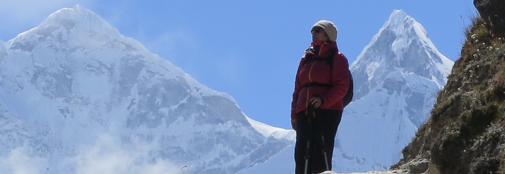
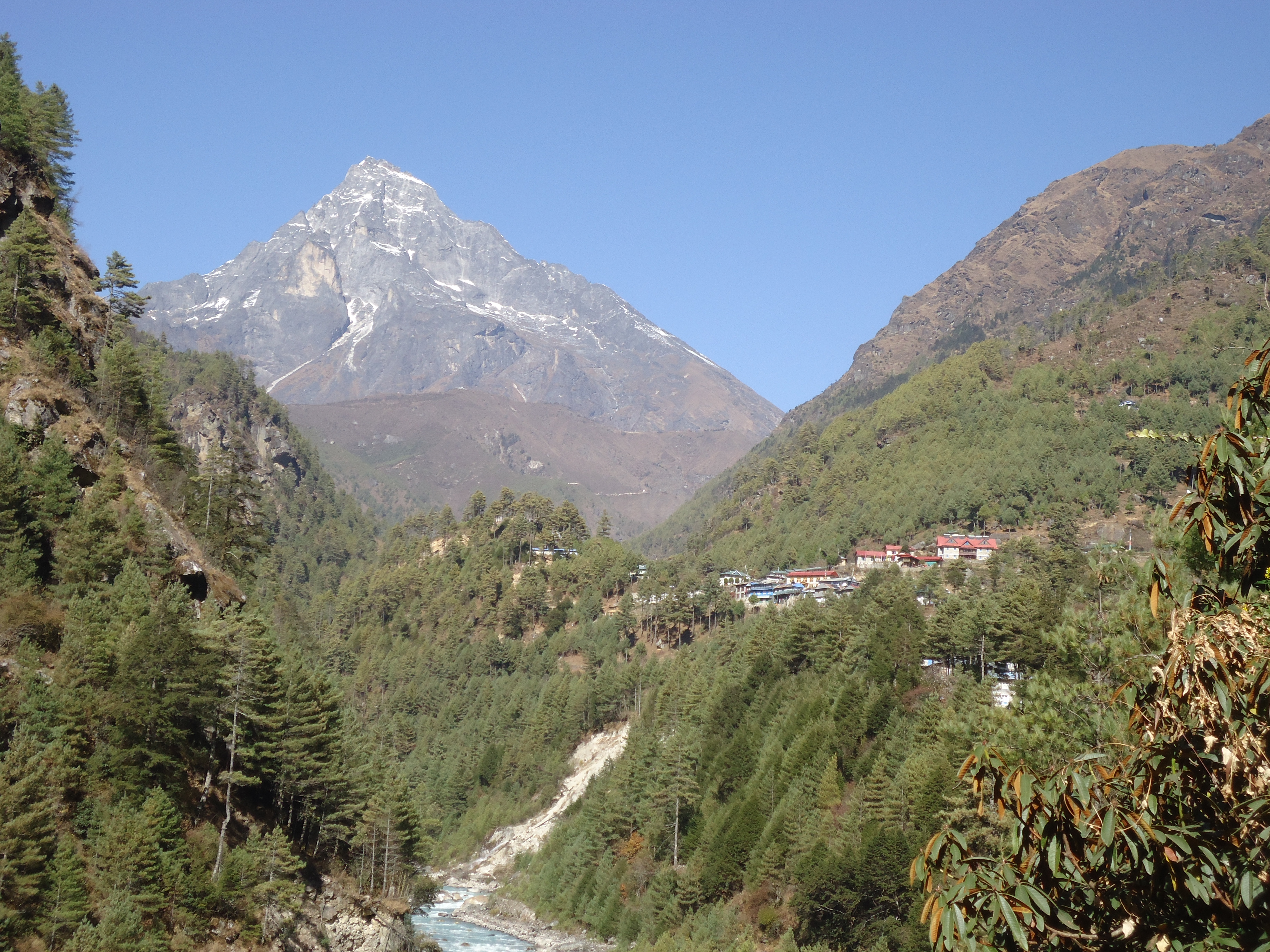
I wanted to be able recognise and name the mountains too, so before our trek in 2015 I studied up on them, well the pictures at least. Apart from Mount Everest which hides a lot until the very end of the trek, Ama Dablam is one of the first mountains you will come to know and recognise wherever you are. The mountains change shape as you move along the trail as your view changes. Ama Dablam is different it has that funny skinny cone shape and later it has an armchair shape. Remember to use your imagination a bit.
Ama Dablam is first visible after Namche Bazaar and there is good view of from Khumjung, above Namche Bazaar. In fact the guide books tells you Ama Dablam towers above Khumjung. And she does. Are mountains referred to as male of female? Well I’m calling Ama Dablam a she as it means Mother’s Chest or Mother’s Treasure Chest meaning a jewel box. And by all accounts she deserves some respect.
Here she is from a different angle and location.
Up for another Everest Base Camp Trek Titbit?
Bridge Too Many or Bridge Love – bridges on the way to Base Camp and some photos

This is Ama Dablam taken from Dingboche taken on our Acclimatisation day in September 2018. You can see the arm chair shape from this angle
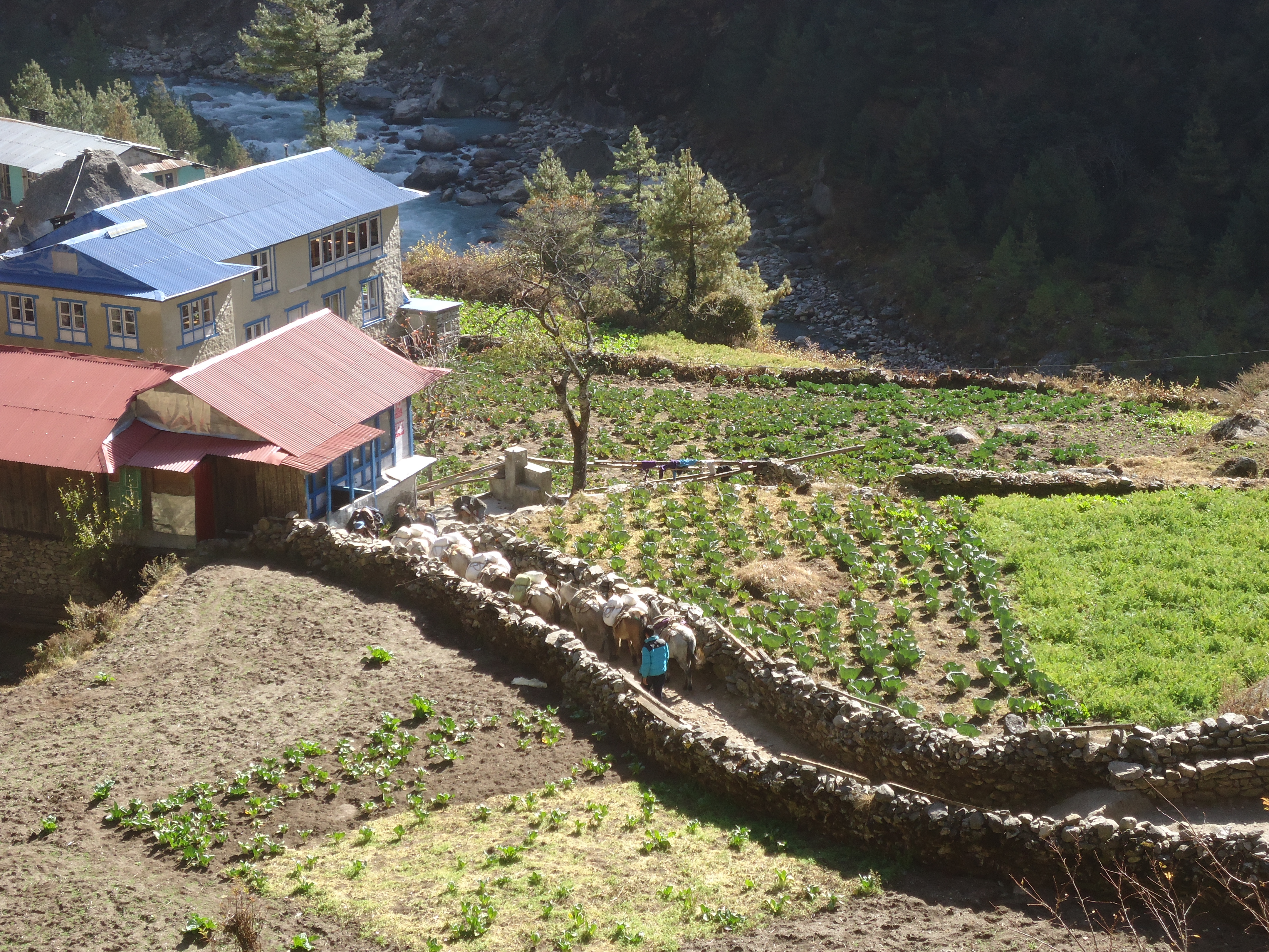
Exploring Monjo
Our lodge in Monjo had an outside area with tables in the sun and an orchard out the back, growing apples of course.
A relaxing place to sit in the sun at the Monjo Guest House.
As it was an easy walk to Monjo and after a hot shower we went for a short walk through the village to take some photos.
Continue reading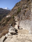
This gallery contains 8 photos.
A big day with amazing views but I would like to ask who was responsible for the “Two Hours to Tengboche” signage? Continue reading
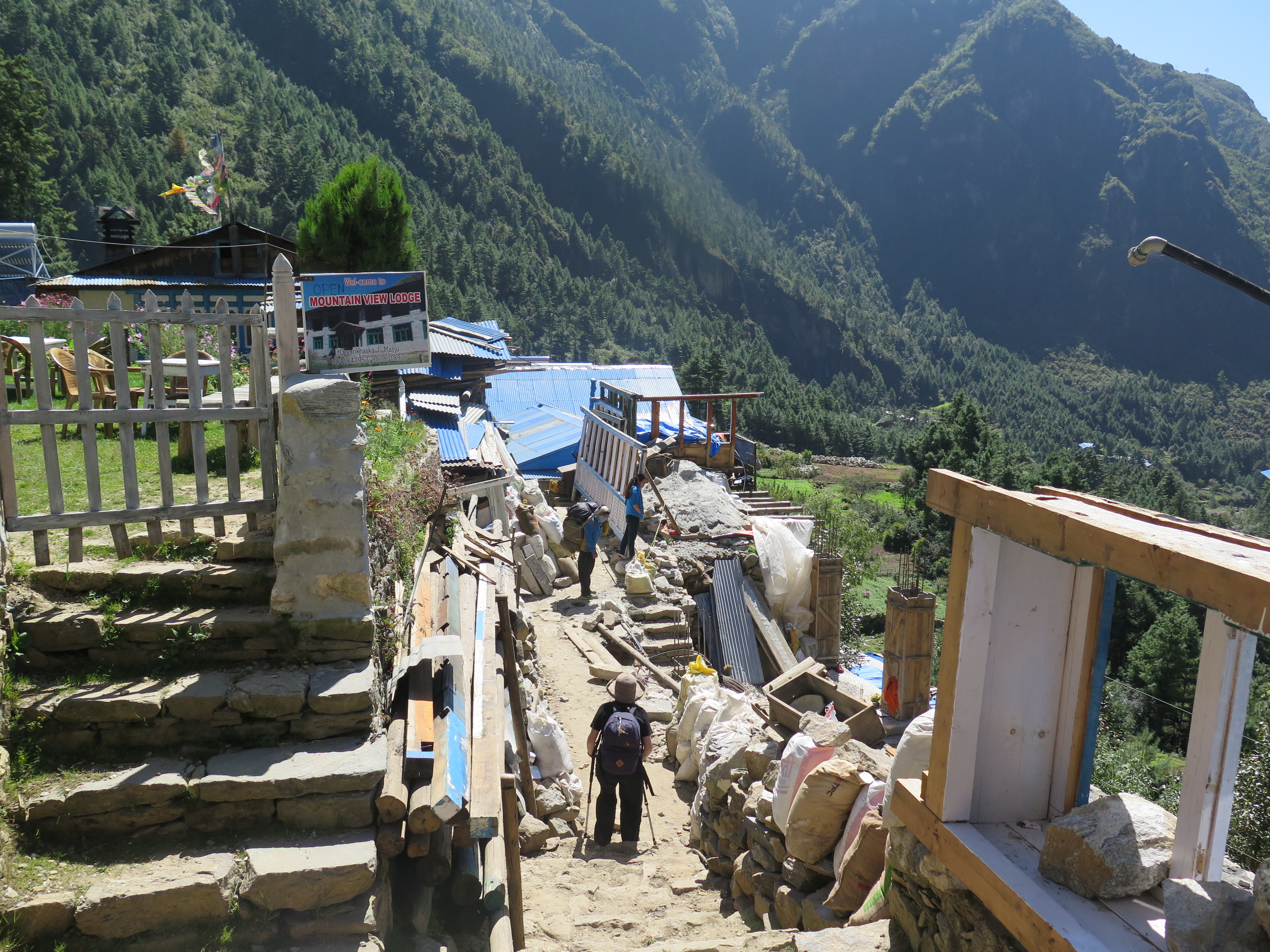
Most treks do Phakding to Namche Bazaar on day two. Before we left Australia, the Trainer decided to add a day to our itinerary and walk to Namche Bazaar on Day 3 instead.We had time and it would be easier on our legs and lungs. I was happy for him to do all the research and planning and trusted his judgement. From my minimal research and a friend’s first hand experience I knew the infamous climb to Namche Bazaar was a hard one. The friend had trekked with group and had been one of the earliest to arrive. He sat in a cafe and watched others from his group walk into the town. One very tough character from their group finally arrived, absolutely exhausted. He came up to my friend with tears in his eyes, hugged him and said that it had been the hardest day of his life. So when we set out from the tea house in Monjo I was mentally prepared and planned to take it slowly.
Just outside of Monjo is the entrance to the Sagarmatha National Park the checkpoint where Trekkers’ Information Management System (TIMS) card details are recorded. TIMS cards no longer exist as such (2018) however there is a permit and a process for registering trekkers.

The Sagarmantha National Park entrance outside Monjo
I realised I wasn’t quite up to the local speed when an older Nepali woman with a load of 40 kilos of cabbages on her back passed me.

The bridge to Jorsale festooned with prayer flags

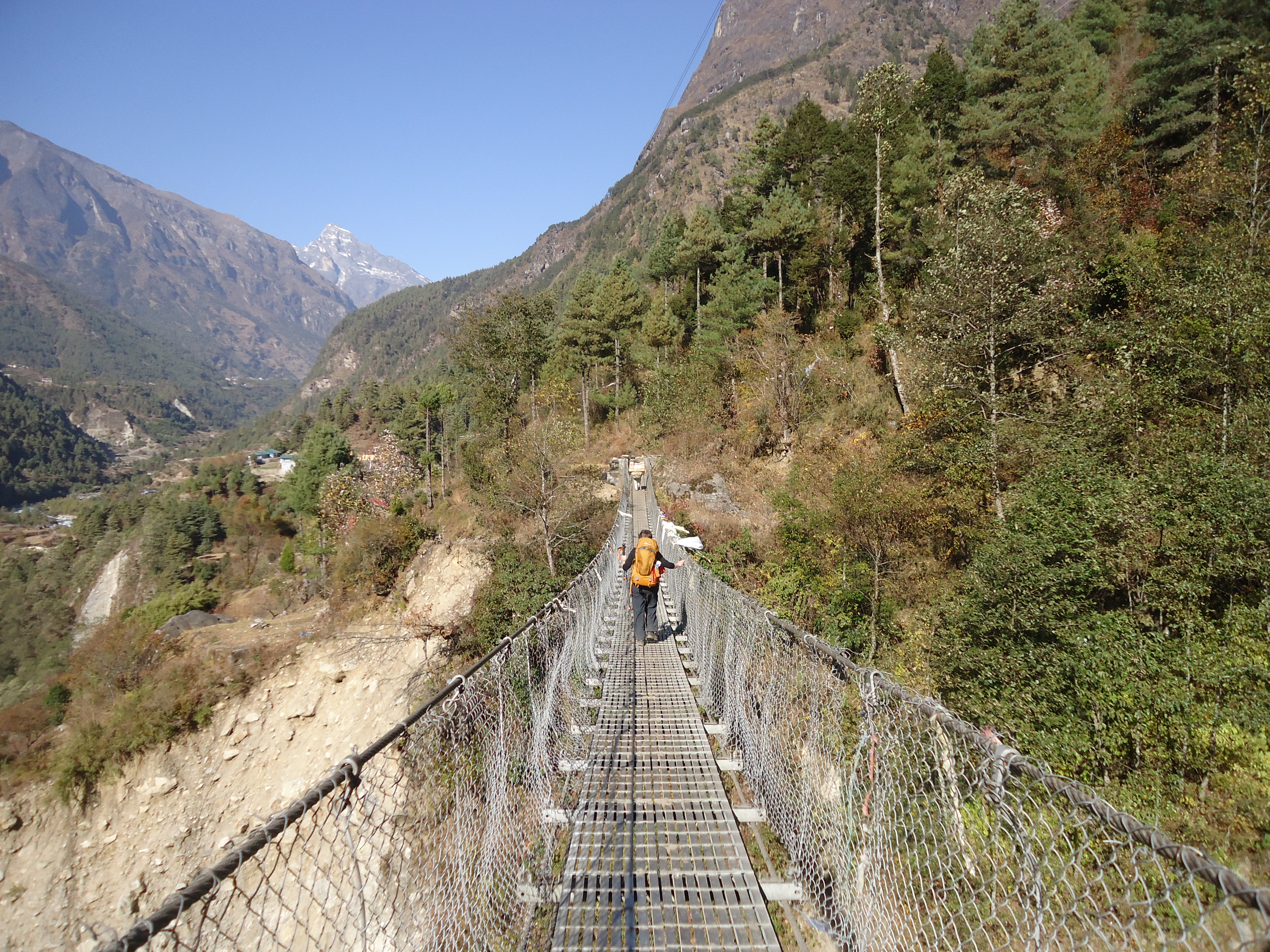
A rest before the climb to the higher bridge at the Dudh Kosi Gorge and famous bridge.

Almost off the high bridge across the Dudh Kosi Gorge

Fruit sellers at the resting place on the climb to Namche Bazaar. there are toilets here and ….
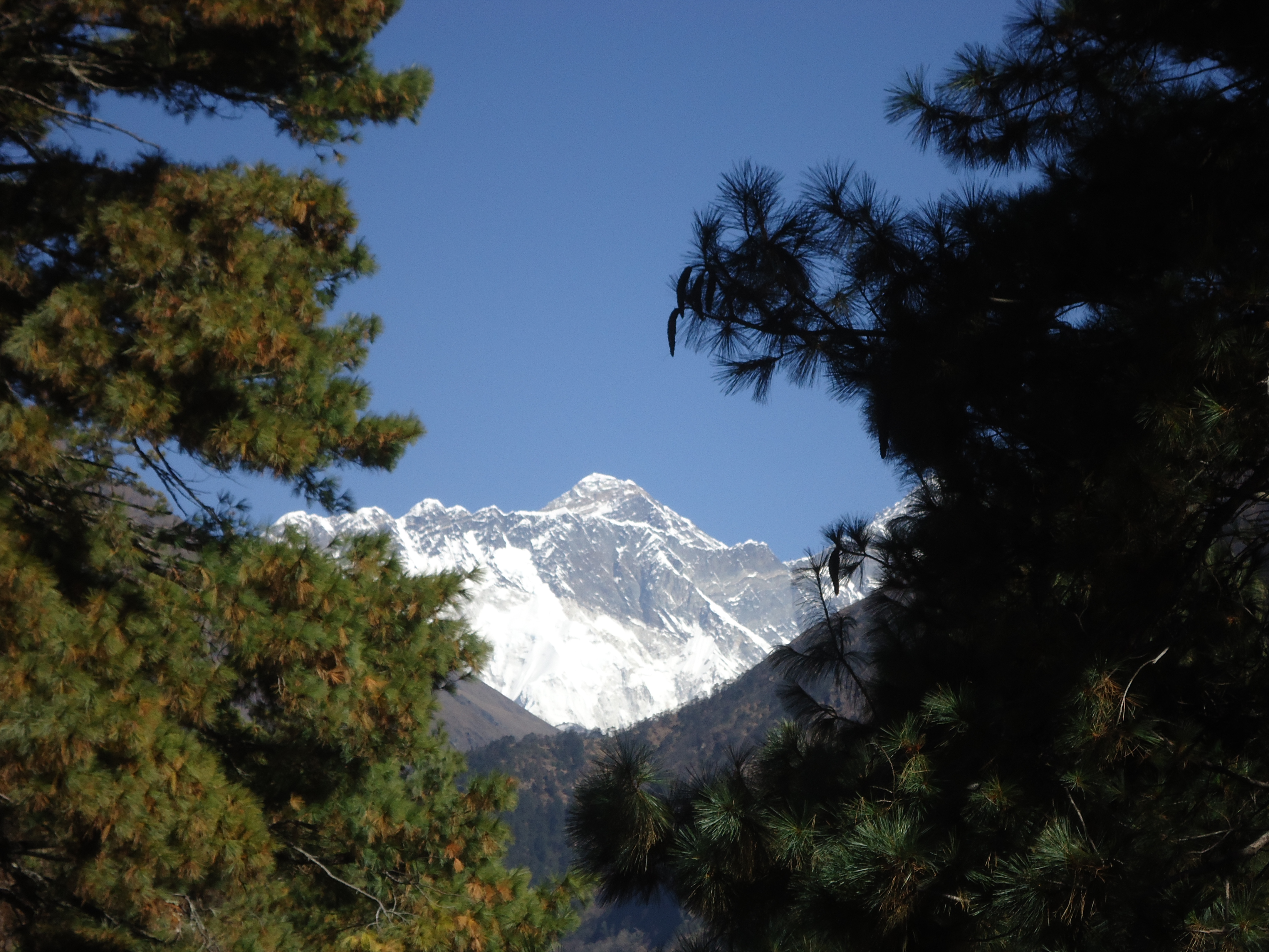
your first view of Everest – one of rewards for the strenuous day’s climb

The trail around the mountain

The infamous climb to Namche Bazaar almost finished.
Follow the Pumpkin Coloured Backpack
This day was a short walk. For many trekking tours Day 2 is Phakding to Namche Bazaar. The climb to Namche Bazaar is a big day so the Trainer added a day to our itinerary so we didn’t need to rush and allow time to acclimatise to the altitude. Groups were leaving our lodge for Namche a good hour before us. Setting out we looked forward to a leisurely day taking our time and taking in the views around us.

Before leaving Melbourne our plans to trek the Everest Base Camp by ourselves and without a guide or porter had a few people concerned. Me as well. The Trainer explained to my mother before we left that trekking the trail is not like trekking a in remote location, well in the lower part of the trail anyway. He explained the trail is through villages with small tea houses dotted all the way, with lots of people trekking, porters and Nepalis going about their daily business including school kids walking to school. We did in fact see many children walking to school along the trail. Small children in small groups without adults running to school had my herd mother radar working on overdrive at times.


Before our 2013 Everest Base Camp trek training and preparation, videos and photos helped get an idea of what the trail is like. A photo I found on Pinterest made me realise the need for step training. The photo below is not what I found, but how I found the trail!


However, the guide book and The Trainer’s overview of the first day’s walk to Phakding didn’t quite match up with the experience. A two – hour easy downhill walk said the guide book. The Trainer had done all the research and his words echoed the book. In the next few days I discovered easy and downhill are relative and how important mental preparation is.
Before we started out for Phakding my idea of downhill was downhill – not up hill and downhill in a general downhill direction. You can see what I mean here with a elevation profile chart of Lukla to Phakding. There are some uphill sections.
It took us about four and half hours walking and I thought we would never get to Phakding. From experience trekking in the Anna Purna region years ago, the Trainer had forewarned me the trail would be uneven and rocky. He had done a great job as personal trainer of designing our training to prepare us for this. The track varied incredibly on the first day from cobblestones in Lukla, to meandering flat paths, to rocky steps and very rocky sections. In the scheme of things Lukla to Phakding is an easy day and after the trek we knew to double the time needed in one guide book. A second guide book we bought in Kathmandu has a handy basic info table with more realistic times in the time usually taken.
The Everest Base Camp trail goes through small villages and is narrow in parts. Shared by trekkers, porters, pack animals (yaks, donkeys and horses) and kids on their way to school it can be busy. I selected the photos to show how the track varies on the first day.

That’s me walking out of Lukla feeling very much the Newbie.

One of the many villages and tea houses along the trail.
That first bridge … always a bit scary

At this spot on the way back down my Nepalese Mobile rang…..so weird
Here is the link to one of the guide book we like we bought in Nepal. Trekking in Nepal’s Everest Region by Milestone Books. The times usually taken between places you stay.
Namche Bazaar 3420 – Khumjung 3780 metres 2.5 hours walk
Khumjung is the largest town in the Khumbu region.

The climb out of Namche is steep and we were in thick cloud. We could not see very far but sounds travelled up the hill to us – the chinking sound of the stone masons and the anthem and then music for a fitness program from the school below. I practiced my newly learnt Tashi Dele greeting, much to the delight of the Sherpas passing us. Possibly they were going down to prepare for the market the following day. The large market on the Saturday is very famous and sadly as we had changed our itinerary and we would miss it. Perhaps next time.
The landscape changes and reminds me of the moors in Scotland. The thick cloud made me focus on the low heath like plants. Spider webs bejewelled with water droplets reminded me not to forget the beauty at the ground level. Consequently, new Nepalese words included putali (butterfly), makura (spider) and makura zal (spiderweb).

I was keen to see that the school built by Edmund Hillary had not been badly damaged by the earth quake which had affected Khumjung. I was pleased to walk into the town and past the school just as the children finished their half day Friday. Sadly, though the gompa near the school had been damaged.

We found a lodge, organised our room and had lunch. Later we walked to the town’s monastery and home of the famous Yeti skull (Wikipedia). The monastery was quite beautiful and worth the visit.
We were the only guests in the lodge and after our dhal bhat we watched a video about the life of Hillary.
We woke in cloud, walked straight up out of Namche in cloud and went to sleep in cloud.
See photos for our walk into Khumjung
