Day Nine Dingboche to Dughla

Day Nine – Dingboche to Dughlia     30 September 2015

Above Periche Between Dingboche and Dughla
Between Dingboche and Dughla

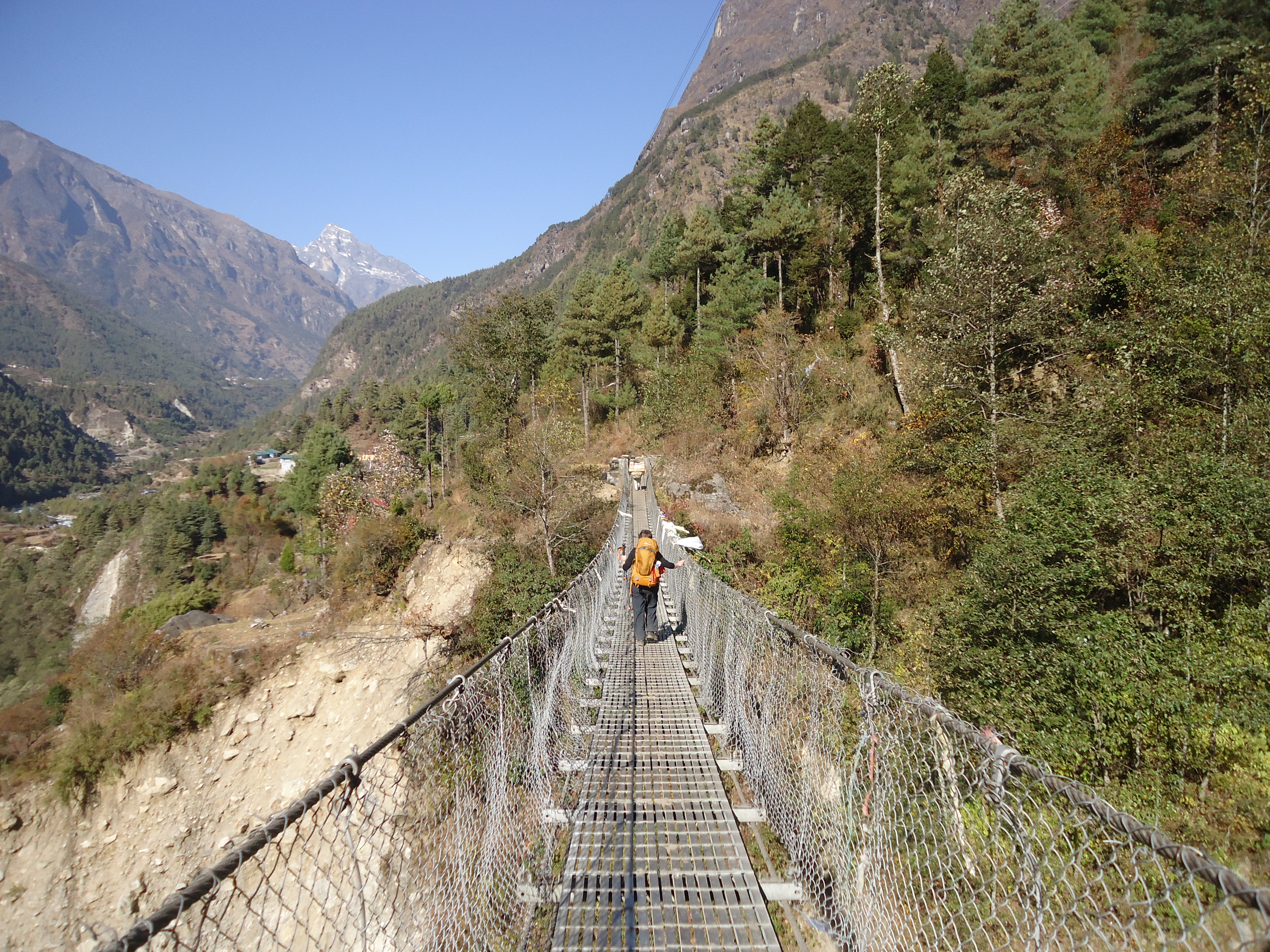
We retraced our steps into the town for the initial part of the walk and then took a trail along the side of the hills past yak pastures and herders’ huts. A few big trekking groups were walking out probably groups doing the trail in fewer days along the main trail.

It was great walk across flat plains, slowly going uphill with great views of Periche below. On the way we saw some teenagers carrying large baskets of dung and Basanta had an animated conversation with them.

After we arrived at Dughla we decided to stay at the Yak Lodge. One of only two lodges there which is probably why people don’t stop there. We had lunch in the sun with the beautiful blue skies and watched as trekkers came down from Gorak Shep. We met the group who had flown on the same flight into Lukla with us including a mother and daughter team from Queensland who flew on the same flight from Kuala Lumpur.

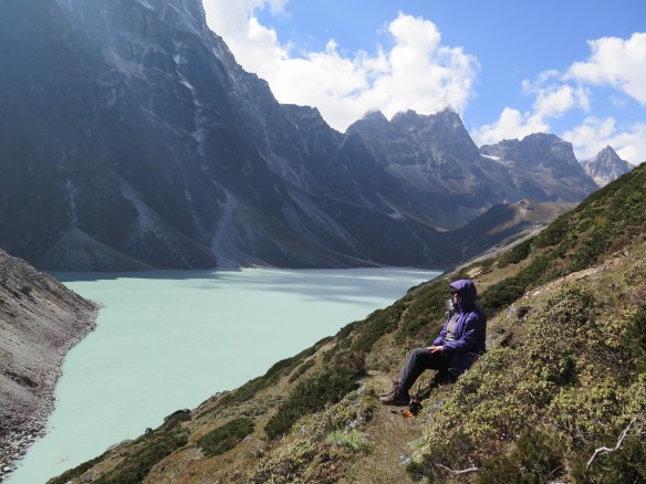
After a rest we walked up behind the lodges for a view of Dughla Lake which was almost completely hidden from view at the lodges. It was a two hour walk and wasn’t really a trail so we picked our way carefully to a good sitting spot. There were lots of juniper bushes growing on the hills. My wind jacket protected me from the cold wind which is why you should pack one even if it is a dry season.

Lake near Dughla Nepal

We stayed at Dughla to make sure we stuck to the rule of not ascending more than 300 metres. We didn’t want to risk altitude sickness and not make EBC.

Day Eight – Dingboche Acclimatisation Day

Climbing Dingboche Ridgetop
Hard and slippery acclimatisation day climb

This day was quite a tough walk above Dingboche to what is called the Dingboche Ridge Top, not that we climbed to the top. The views were magnificent and we had time to sit and enjoy them.

Continue reading

Day Six Phortse to Shomare

Everest Base Camp Trek

Heads in the Clouds

Clouds blocking a great view

Sitting in cloud hoping it would lift

We walked up out of Phortse and then up forever. At the top it was very cloudy (dherai mukpa) which was disappointing as the views would have been spectacular but because we were trekking at the very end of the monsoon season there were still clouds around and we could not see a thing.

At Pangboche and went inside the monastery or gompa here while our lunch was being cooked. It is the oldest monastery in the Khumbu.

We came in and walked out of Pangboche a totally different way from our 2013 trek. Our impression walking in was of quite a different village. The walk out past the helicopter rescue pad and lots of chortens and mani stones was interesting and the cloud broke and we had some sneak mountain views at last.  Continue reading

Ama Dablam Nepal

Everest Base Camp Mountain Cameo

Ama Dablam from the Everest Base trek
Ama Dablam photo taken between Namche Bazaar and Tengboche

On our first flight to Lukla, as we flew along the Himalayas mountain range, a European man in his seventies, pointed out the names of various mountains to my husband who was sitting across the aisle from him. I was impressed. This guy knew his mountains. It was his seventeenth trek to Nepal. Warning: trekking in Nepal is addictive.

I wanted to be able recognise and name the mountains too, so before our trek in 2015 I studied up on them, well the pictures at least. Apart from Mount Everest which hides a lot until the very end of the trek, Ama Dablam is one of the first mountains you will come to know and recognise wherever you are. The mountains change shape as you move along the trail as your view changes. Ama Dablam is different it has that funny skinny cone shape and later it has an armchair shape. Remember to use your imagination a bit.

Ama Dablam is first visible after Namche Bazaar and there is good view of from Khumjung, above Namche Bazaar. In fact the guide books tells you Ama Dablam towers above Khumjung. And she does. Are mountains referred to as male of female? Well I’m calling Ama Dablam a she as it means Mother’s Chest  or Mother’s Treasure Chest meaning a jewel box. And by all accounts she deserves some respect.

Here she is from a different angle and location.

Up for another Everest Base Camp Trek Titbit?

Bridge Too Many or Bridge Love – bridges on the way to Base Camp and some photos

Ama Dablam from Dingboche, Nepal
.

This is Ama Dablam taken from Dingboche taken on our Acclimatisation day in September 2018. You can see the arm chair shape from this angle

Bridges Along the EBC Trail

Updated post January 2020 with photo of bridge at Dughla.

The two bridges to Namche Bazaar

Too Many Bridges or Bridge Love

Love them or not, the Everest Base Camp Trek has many bridges to cross. The first one is scary and they get easier to cross as you go. For the personal trainer it was Bridge Love. He stood in the middle of the bridges looking over the edge enjoying the wind and the rush of water underneath. He put on his documentary maker’s hat and strolled across filming, making his commentary against the roar of the water underneath. One time he threw the camera at me and asked me to video him crossing the bridge. Not my idea of fun especially when he started jogging on the bridge while I was on it filming.

Yes bridges weren’t my favourite part of the trek. I remember the first bridge at Chheplung, being nervous and very glad when I was on the other side. It does get easier as there are quite a few bridges and then you cross them again on the way back down to Lukla.

Continue reading

Day 2 2013 Taking It Slowly on the EBC Trail

Exploring Monjo

Our lodge in Monjo had an outside area with tables in the sun and an orchard out the back, growing apples of course.

Monjo Guest House EBC Trek

A relaxing place to sit in the sun at the Monjo Guest House.

As it was an easy walk to Monjo and after a hot shower we went for a short walk through the village to take some photos.

Continue reading

Day 1 Lukla to Phakding

Our 2013 Trek to Everest Base Camp

The EBC trek. Me the over 50s anxious woman and her husband “The Trainer” starting out from Lukla. Well prepared newbies on the trail.

Before our 2013 Everest Base Camp trek training and preparation, videos and photos helped get an idea of what the trail is like. A photo I found on Pinterest  made me realise the need for step training. The photo below is not what I found, but how I found the trail!

However, the guide book and The Trainer’s overview of the first day’s walk to Phakding didn’t quite match up with the experience. A two – hour easy downhill walk said the guide book. The Trainer had done all the research and his words echoed the book. In the next few days I discovered easy and downhill are relative and how important mental preparation is.

EBC Trek Trail What I Learnt on Day One

Before we started out for Phakding my idea of downhill was downhill – not up hill and downhill in a general downhill direction. You can see what I mean here with a elevation profile chart of Lukla to Phakding. There are some uphill sections.

It took us about four and half hours walking and I thought we would never get to Phakding. From experience trekking in the Anna Purna region years ago, the Trainer had forewarned me the trail would be uneven and rocky. He had done a great job as personal trainer of designing our training to prepare us for this. The track varied incredibly on the first day from cobblestones in Lukla, to meandering flat paths, to rocky steps and very rocky sections. In the scheme of things Lukla to Phakding is an easy day and after the trek we knew to double the time needed in one guide book. A second guide book we bought in Kathmandu has a handy basic info table with more realistic times in the time usually taken.

The Everest Base Camp trail goes through small villages and is narrow in parts. Shared by trekkers, porters, pack animals (yaks, donkeys and horses) and kids on their way to school it can be busy. I selected the photos to show how the track varies on the first day.

EBC Trek Walking out of Lukla

That’s me walking out of Lukla feeling very much the Newbie.


Lukla to Phakding Everest Base Camp Trek

One of the many villages and tea houses along the trail.


Lukla to Phakding Everest Base Camp Trek

That first bridge … always a bit scary


Lukla to Phakding Everest Base Camp trek

At this spot on the way back down my Nepalese Mobile rang…..so weird

Here is the link to one of the guide book we like we bought in Nepal. Trekking in Nepal’s Everest Region by Milestone Books. The times usually taken between places you stay.


Day Four Namche Bazaar to Khumjung

Steep Climb Through the Clouds

Friday 25 September 2015

Namche Bazaar 3420 – Khumjung 3780 metres 2.5 hours walk

Khumjung is the largest town in the Khumbu region.

Khumjung Everest Base Camp trek September 2015
Walking into Khumjung

The climb out of Namche is steep and we were in thick cloud. We could not see very far but sounds travelled up the hill to us – the chinking sound of the stone masons and the anthem and then music for a fitness program from the school below. I practiced my newly learnt Tashi Dele greeting, much to the delight of the Sherpas passing us. Possibly they were going down to prepare for the market the following day. The large market on the Saturday is very famous and sadly as we had changed our itinerary and we would miss it. Perhaps next time.

The landscape changes and reminds me of the moors in Scotland. The thick cloud made me focus on the low heath like plants. Spider webs bejewelled with water droplets reminded me not to forget the beauty at the ground level. Consequently, new Nepalese words included putali (butterfly), makura (spider) and makura zal (spiderweb).

IMG_1010

I was keen to see that the school built by Edmund Hillary had not been badly damaged by the earth quake which had affected Khumjung. I was pleased to walk into the town and past the school just as the children finished their half day Friday. Sadly, though the gompa near the school had been damaged.

Stupa at Khumjung in the Khumbu region of Nepal
Sadly the earthquake damaged the stupa at Khumjung

We found a lodge, organised our room and had lunch. Later we walked to the town’s monastery and home of the famous Yeti  skull (Wikipedia). The monastery was quite beautiful and worth the visit.

We were the only guests in the lodge and after our dhal bhat we watched a video about the life of Hillary.

We woke in cloud, walked straight up out of Namche in cloud and went to sleep in cloud.

See photos for our walk into Khumjung

Day Three Namche Bazaar Acclimatisation Day 2015 Trek

Altitude Acclimatisation or Rest Day ?

It is best to think of the acclimatisation day involving some walking above where you are going to sleep. We walked above Namche Bazaar to the helicopter landing strip and quarry. The day was cloudy and the sound of rocks being chiselled for structures over the stream near the stupa rang out across the arena shaped town.

We also visited the monastery and turned some of the many prayer wheels on the way up. On the path to Khunde we sat on a large flat boulder and looked out over the pines and down to the river way below.

After our walk at one of the town’s bakeries I remembered meeting a French woman in 2013 who had spent what I was still calling a rest day walking up to Khunde and Khumjung and back down to Namche. At the time I thought she was mad but she was walking to Base Camp in less days than us and so walking the large circle up to Khunde and Khumjung would have helped with her walk to Tengboche’s altitude the following day. I now know better than to call it anything else but an acclimatisation day.

For our 2015 trek we had decided to sleep a night at Khumjung. This was not the original itinerary. We had planned to sleep our second night in Monjo but we reached there by 11:00 and were feeling great so we decided to continue and climb to Namche Bazaar. We had our two nights in Namche Bazaar and then using the day up our sleeve on the following day we were then able to walk to Khumjung and sleep at a slightly higher altitude allowing us more acclimatisation time for the altitude. I am sure this extra day was one of the keys to successfully arriving at EBC without any issues.

 I now know better than to call it anything else but an acclimatisation day.

Trekking independently with a porter gave us the flexibility to make this change of itinerary.

Below are photos taken on our Acclimatisation Day on 24 September 2015.

Namache Bazaar, Main Trail Everest Base Camp Trek
Looking out onto Namche Bazaar
Namache Bazaar, Main Trail Everest Base Camp Trek
Above Namche Bazaar on the path to Khunde
Pines above Namche Bazaar September 2015
Stunning large black pine cones
Monastery at Namche Bazaar
Monastery Entrance

Day Five Namche Bazaar to Tengboche 2015 Trek

Two Hours to Tengboche

I knew that Day 3 of our itinerary, climbing to Namche Bazaar would be strenuous. We trained well and  though it wasn’t easy we managed the climb well.

When we set out two days later for Tengboche, Sam told me it would be a relatively easy day. That proved far from the case. We had a breather at the top of Namche after a steep climb out of the amphitheatre – shaped town. After a few more challenging hills with spectacular views, the track really leveled out. That bit was the honeymoon period.

The trail then descends 570 metres to the river after crossing this, there is a relentless 750 metres 2-3 hours climb (according to the guide book) to Tengboche. I am sure this section would have taken us much longer.

The funniest bit was the signage. Not far from Namche there was sign “2 hours to Tengboche”. Two hours further along the track there was another sign “2 hours to Tengboche” and then about another two hours further on, you guessed it – “2 hours to Tengboche”. Hence the comment on the video and the post title. At one point we stopped to catch our breath. Another trekker was doing the same with his guide waiting for him. When we asked the guide how much longer to the top, what do you think he replied? I couldn’t believe it.

On that day I learned mental preparation is everything. I had heard it said in relation to physical challenges but didn’t relate to it until then. For our next trek to Everest Base Camp we will be prepared for the two hours to Tengboche. In fact we are changing the itinerary to start the trek from Khunde or Khumjung and not Namche. The other tip is don’t believe the estimated trekking time between the towns and definitely don’t believe the signage.

Day Two Phakding to Namche Bazaar 2015 Trek

The Traditional Day Two of the EBC Trail

  • 23 September 2015
  • 8:10 am – 4:00 pm
  • 2610 – 3440 metres
  • 830 metres ascent
  • option of staying at Monjo was factored into the itinerary

We weren’t in a hurry to leave the lodge and trekking independently we had the luxury of doing so because we had our own porter and we would decide when to leave.

The weather was a cool and there was a fine rain threatening. We knew what was involved in the climb ahead and we knew we had time.

View from room Lodge at Phakding
We were always grateful to have windowsill in our room because that somewhere to have our things and provide some organisation for the contents of our pack.


Day two of the main trail to Kala Patthar and the Everest Base Camp
Early morning mist outside of Phakding
DAmp stone trail outside of Phakding on the way to Namche Bazaar
Just outside of Phakding

Day One Lukla – Phakding 2015 Trek

Kathmandu-Lukla-Phakding (2610m)
8.5 km 3.5 – 4hours

  • Flying into Lukla
  • Remember downhill is never just downhill
  • Beautiful little villages
  • 8.5 km walk, took 4 hours in 2013, 3.5 hours in 2015
  • Lukla to Chheplung took us one hour
  • First bridge at Thado Kosi Gaton
  • Om Mane Padme Hum

Day One on 2013 Trek
Day Two on 2015 Trek
Itinerary 2015 Trek

Flying to Lukla
Main Street Lukla, setting out on Main Trail EBC Trek
Lukla to Phakding
Ghat on the Main Trail Lukla to Kala Patthar and Everest Base Camp
Main Trail to Kala Patthar and EBC
Main trail Lukla to Kala Patthar at Phakding

Day Eleven Lobuche to Gorak Shep 2015 Trek

Gorak Shep Next Stop EBC

What does it mean to trek to Everest Base Camp? Do you actually stay there? Not unless you want to sleep in a tent on very cold rocky ground and climb Mount Everest. Which incidentally is barely visible from Everest Base Camp (5300m).

The best place to see Everest from is from Kala Pattar (5545m). How do you get there? From Gorak Shep (5170m), the end of the trail for the average person. Not that you feel very average after walking from eight to eleven days to get there. It feels like walking to the Middle Earth.

Gorak Shep is pretty average when it comes to accommodation. Situated on what was once a lake it has a handful of lodges. But at that stage of the trek you just want a warm bed and a toilet and somewhere to have three meals – lunch, dinner and breakfast usually in that order and to go to what will possibly be the two most special and remote places you will go to in your lifetime. And when you have been there you will want tell the world.

Apart from walking to Base Camp also abbreviated to EBC the best part is the Himalayas spread before you in the most magnificent vista that will be hard to top. You see this from what I discovered was a fairly insignificant looking “hill” of which I had never seen a photo of. So here is one, so you know what you will climb to see that view.

Gorak Shep the end of the Everest Base Camp trek
Walking into Gorak Shep the end of the Everest Base Camp Trek

Looks insignificant in the scheme of things with all the massive mountains around it. Innocent even. But that little brown in the middle ground, Kala Pattar is 5545 metres high. It takes two hours to climb to the top, an elevation of 375m from Gorak Shep  via the trail on the right. The snow covered mountain in the middle is Pumori.

Louise and Sam Terranova were at Everest Base Camp at the very start of the trekking season after the Nepal earthquakes on 2 October 2015. Lodges had been repaired and the Khumbu was ringing with the sound of stonemasons building new lodges and repairing others along the trail.

A note about Pumori the big triangular mountain in the middle, it is off this mountain that the avalanche came as a result of the April 2015 earthquake. It dumped snow at Base Camp.

You can read an account from Svati Narula who was at Base Camp when the quake hit.

At Everest Base Camp

Louise Terranova with a man in a yellow wig at Everest Base Camp.
The yellow wig made it to Everest Base Camp too.

Yes that’s me. On the lap of a man with a yellow wig on. At Everest Base Camp.

In my mind’s eye I had pictured it. For over twelve months we had planned it and for six months we had trained hard for it.

We paid for the air tickets a week before the first quake. Twice we decided to cancel the trip, the second time only a month before we were to depart. But we had trained so hard and planned for so long, it was something we had to do, it didn’t feel right to cancel.

Back home with stories, memories and photos that still bring tears to my eyes it is without doubt one of the best things I have ever done. It is an amazing experience and the Everest Base Camp trail and the Khumbu is ready for trekkers. So if you have ever thought of doing it, think no longer, just do it. Train and prepare for a life changing experience.

Oh and the wig – it was a big hit at EBC and borrowed  for photos that will adorn shelves in Japan and India just to name a few.

Louise Terranova trekked to Everest Base Camp, 23 Sept- 8 Oct 2015

Day 5 Namche Bazaar to Tengboche 2013 Trek

Video

Two Hours to Tengboche

I knew climbing to Namche Bazaar on Day Three of our itinerary, was going to be a strenuous. We trained well for the trek and though it wasn’t easy we took the climb in our stride.

When we set out two days later for Tengboche, the Trainer told me it would be a relatively easy day. That proved far from the case. We had a breather at the top of Namche after a steep climb out of the amphitheatre-shaped town.

Namche Bazaar Everest Base Camp Trek
Namche Bazaar

After a few more challenging hills with spectacular views, the track really levelled out. That bit was the honeymoon period.

The trail then descends 570 metres to the river, after crossing this, there is a relentless 750 metres two to three hours climb (according to the guide book) to Tengboche. I am sure this section took us much longer.

The biggest problem was the signage. Not long out of Namche there was sign which said “2 hours to Tengboche”. Two hours further along the track there was another sign “2 hours to Tengboche” and then about another two hours further on, you guessed it – “2 hours to Tengboche”. Hence the comment on the video and the post title. At one point after the third sign, we stopped to catch our breath. Another trekker was doing the same with his guide waiting for him. When we asked the guide how much longer to the top, what do you think he replied? I couldn’t believe it.

That day I learnt mental preparation is everything. I had heard it said in relation to physical challenges but had never really experienced it. For our next trek to Everest Base Camp we will be prepared for the “two hours to Tengboche”. In fact we are changing the itinerary to start the trek from Khunde or Khumjung and not Namche. The other tip is don’t believe the estimated trekking time between the towns and definitely don’t believe the signage.